


Chapelle Sainte Appolonie

pb07
User

Length
8.6 km

Max alt
319 m

Uphill gradient
330 m
Km-Effort
12.8 km

Min alt
130 m

Downhill gradient
292 m
Boucle
No
Creation date :
2024-11-22 13:43:36.219
Updated on :
2024-11-22 17:48:51.773
2h20
Difficulty : Difficult

FREE GPS app for hiking
 SityTrail
IGN / Geographical institutes
SityTrail Plus
The world is yours!
About
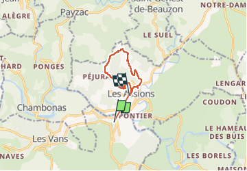
Trail Walking of 8.6 km to be discovered at Auvergne-Rhône-Alpes, Ardèche, Les Vans. This trail is proposed by pb07.
Positioning
Country:
France
Region :
Auvergne-Rhône-Alpes
Department/Province :
Ardèche
Municipality :
Les Vans
Location:
Chassagnes
Start:(Dec)
Start:(UTM)
592804 ; 4918246 (31T) N.
Comments